- Robert Colbourne
- About
- Working
- Loading Bay Pocket Park
- Exchange
- 29-32 Mary Street
- King Edward VI Sixth Form College
- Tamed [Flood Management Scheme]
- Smithfield Site
- Frames - King Edward VI College
- James Watt Campus, Birmingham Metropolitan College
- Kemble Airfield
- Fargo
- Woodthorne Residential Housing Development
- Muchall Grove Housing Development
- Gravesend
- Meshwork Worcester
- Quadrant, Network Rail National Centre
- 20ft to an Inch [Sustrans]
- Birmingham Coach Station, Digbeth
- South Wolverhampton and Bilston Academy
- Longton Plots
- Pride of Place, West Bay
- Darwin Hall
- Light in Benmore - Optima Housing Association Art-as-Maintenance Report
- Smithfield 1 Proposal
- Interchange
- Turning Wall
- Springfield Brewery
- Constellations, Optima Housing Association
- AFC Telford United
- Stourport Day Book
- Stourport markers
- Changing Landscapes
- Rea Park, Digbeth
- Rea Crossing, Digbeth High Street
- Green Bridge Feasibility Project
- BryantPriestNewman 10
- Longhouse CPD, Confluence and Mythe
- Landscapainting
- Rd
- At any specific
Kemble Airfield, Kemble [2014]
Study for a new housing development. With Define.
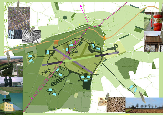
At Jackament's bottom near the edge of Limekiln Hill there is an unusual turn in the Fosse Way. We pondered on this turn and wondered why a decision had been made to change the angle or bearing of direction. Such a simple anomaly seemed to form the beginnings of a place. I imagined seeing it as landmark from above, like a pilot, to find this location or to navigate to other places. I began to look at the fundamentals of aircraft navigation, turning points, visual landmarks, bearings and invisible radial measurements from VHF Omni Directional Radio Range (VOR) stations that connect one place relative to another. Perhaps there are both geographic and geometric connections between the Fosse way turn; the zig-zag path of an aircraft; the historic landscape of wayfinding coverts , plantations and copses; the Thames's origin as it springs from the Cotwolds; and the functional geometry of the airfield.