- Robert Colbourne
- About
- Working
- Loading Bay Pocket Park
- Exchange
- 29-32 Mary Street
- King Edward VI Sixth Form College
- Tamed [Flood Management Scheme]
- Smithfield Site
- Frames - King Edward VI College
- James Watt Campus, Birmingham Metropolitan College
- Kemble Airfield
- Fargo
- Woodthorne Residential Housing Development
- Muchall Grove Housing Development
- Gravesend
- Meshwork Worcester
- Quadrant, Network Rail National Centre
- 20ft to an Inch [Sustrans]
- Birmingham Coach Station, Digbeth
- South Wolverhampton and Bilston Academy
- Longton Plots
- Pride of Place, West Bay
- Darwin Hall
- Light in Benmore - Optima Housing Association Art-as-Maintenance Report
- Smithfield 1 Proposal
- Interchange
- Turning Wall
- Springfield Brewery
- Constellations, Optima Housing Association
- AFC Telford United
- Stourport Day Book
- Stourport markers
- Changing Landscapes
- Rea Park, Digbeth
- Rea Crossing, Digbeth High Street
- Green Bridge Feasibility Project
- BryantPriestNewman 10
- Longhouse CPD, Confluence and Mythe
- Landscapainting
- Rd
- At any specific
Tamed [2013-16]
"From the Environment Agency perspective this project is a way to explore new models of consultation, collaboration and design which could inform future methods for public works. This residency is an opportunity to test the potential for artist collaboration with design teams on engineering projects."
Design team working with Stuart Mugridge, Jenni Coles-Harris, the Environment Agency, Jacobs, CH2M Hill, Townscape and Jacksons-Civils.
The Tame is one of the Celts' dark rivers. The Tame has become one of Birmingham's forgotten rivers. Forgotten by most, that is, apart from when it leaves its narrow confines and floods homes and businesses. Over time, the river gave identity to Witton: powering industry; siting crossings for Roman highways; inspiring poets; watering farms; feeding the canal, providing a habitat for wildlife; and of course, flooding the meadows. In a sense, this flashy river "does nothing, absolutely nothing, but be itself", as Nan Shepherd once said of a mountain spring.[1]
Vision
The river's canalisation began over 60 years ago, having a combined detrimental effect on flooding, ecology and socio-economic factors, despite the vision and forewarning of Herbert Henry Humphries and his Tame Basin Joint Committee in the 1920s.[2] In an effort to reinterpret this initiative and in response to the now limited options of flood management for Witton, we began to encapsulate all activities under a place-shaping 60 year vision, tying into the intended 60 year life span of the intended flood wall, and notions of 'access'. [3] Our aim was to break a pattern of engineering-dominant place-shaping to help the town begin to face the river again, in the hope that the river will be more of an asset and less of a burden to those living in the area in 60 years time.
Activity
Together with on-site exploration, creative engagement (with individuals, a local flood action group and local schools), aimed to increase awareness of the scheme, inform decision-making and initiate conversations on how the river could be used into the future.
Research led us to The Birmingham Typographic Hub and Witton's Kynoch Ltd [former ICI works] that was once home to one of this country's leading printing houses. The Kynoch Press was part of an early twentieth century triumvirate that ruled printing and publishing in Britain and even had an international impact. It attracted and nurtured great designers and typographers to give industrial commissions a touch of inspiration and grace far beyond the capability and knowledge of many modern businesses. The heyday of the Kynoch Press was through the 1920s, '30s and '40s but the business did continue in some form until the recessions of the 1980s.
This resulted in art-thinking irrigating many areas of the scheme.Flood Management Wall- Accessing a Sense of Place
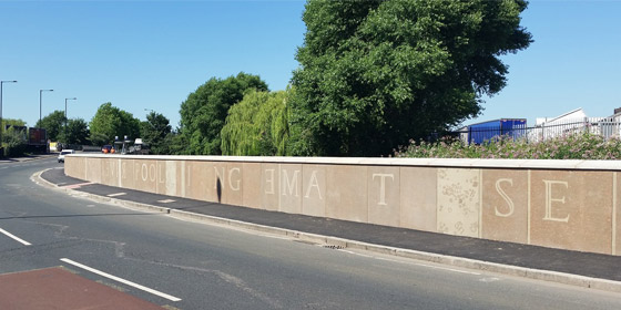
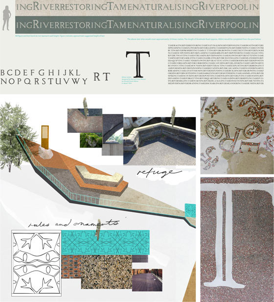
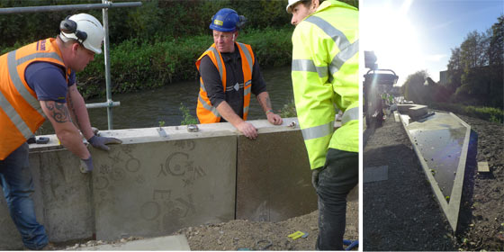
The solution of a flood wall along Brookvale Road could not be avoided. However through the design-team process we began to see the merit in a line of graphic concrete text printed in Milner Initials; a face designed for The Kynoch Press in the 1920s by Donald Ewart Milner. Huddersfield-born Milner was also one-time headmaster of Aston School of Arts and Crafts. Who better than Milner to lead visitors and residents alike into the secrets that Witton holds, and also to give the river a voice again?
Inspired by a printer's compositor block, notions of 'tracking' and the layout of flood wall-panels, gerunds are arranged between the once interchangeable terms of 'River' and 'Tame' to emulate the riffle, pool and run actions of a river. The chosen words have no hierarchy or beginning or end. They aim to carry the river's past and future both literally and symbolically, in the hope that they can inspire enough activity to eventually see the Tame as the 'babbling brook' it was once said to be.
Interrupting the text are panels of randomly placed Kynoch Press page decorations and letters from the faces of Milner and Ravilious. These forms apparently float and cluster in the way that matter suspended in water does so. The water's turbidity is shorthand for myriad lives and particles that are swept along in the River's flow, indicating its health beyond the notice of the human eye.
The rhythm of the railing is taken from a typographers rule. The uprights are spaced to represent the picas and points- the pica contains twelve point units of measure. The units are still widely-used today in printing of both the traditional variety and the digital. Coping stones are is inspired by the angles and geometries of the cutwaters and refuges on Perry Bridges' Zig-Zag Bridge.

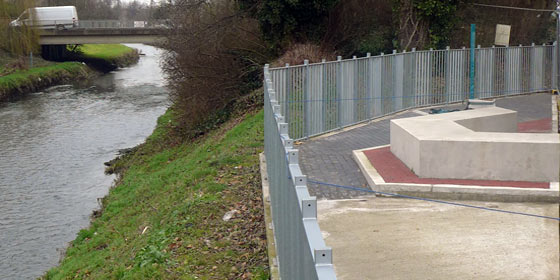
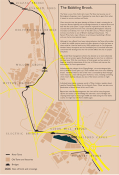
Viewing Platform- Visual Access
From the earliest stage and in accordance with aspirational documents and policies, we felt that any flood mitigation scheme should become a catalyst for people to engage with the river directly. On-site investigation had allowed us to document the zig-zag refuges of Perry Bridge being used as meeting places, small picnic areas and seating. The ratios, angles and cutwaters of the Bridge became a source of geometry for building landscaped meanders: challenging the formal linear engineering of the river corridor. We began to propose sequential viewing areas at key sites, often of historical or ecological significance. Wherever possible we used the zig-zag geometry as a way to retain trees from the line of the intended wall or as a way to sculpt ramps and steps down to an aspirational cycle path.
The eventual proposals included a main viewing platform on Brookvale road, close to fording point that also used to be known as 'Willow Grove'. The area also links to a prominent bus stop. Through our research we learned that local people often take glimpses up and downstream when they waited for the bus, so this became a way in which to enhance and celebrate that experience.
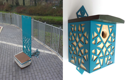
Patterns, materials and colour palettes were chosen to reference both the local vernacular and the Kynoch Press- including designs by Tirzah Garwood and a stunning orange-red discovered in varying literature printed by Kynoch in the twentieth century.
A River Trail - Physical Access
Although many of our physical access points were not taken forward, studying greenspaces, wildlife, existing informal access points, past tributaries, canal connections and historical crossings meant that we could promote a trail along the riverside based on various important locations.
We proposed a series of birdhouses and signs that echo the design of the viewing platform, mark some access points, and link to a map and interpretation board at the Willow Grove site. This part of the project will be completed with a final 'Witton News' publication and the aid of local people as part of a seed-bombing and duck-feeding walk.
Notes:
[1]N. Shepherd, The Living Mountain (Edinburgh, Canongate: 2008), 17.
[2]"It is believed that the carrying out of the scheme of regional drainage would result in making the river an asset to the amenities of the area as such rivers used to, and still should be." Some Drainage Problems in the Birmingham Area, by Herbert H. Humphries, M.Inst.C.E., City Engineer, Birmingham. (Fellow.) The Journal of the Royal Society for the Promotion of Health 1928 49: 642
[3]Access for All Design Guide, Environment Agency 2012